Kayaking to D’Arcy Island, a Former Leper Colony
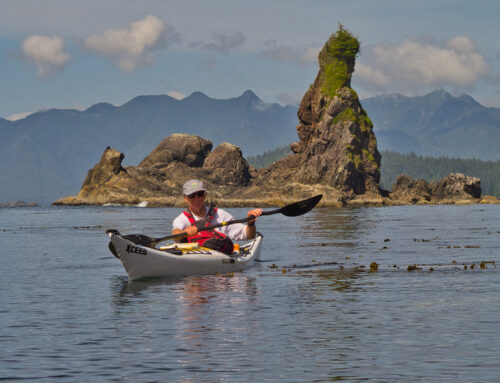
D’Arcy Island, lies just of the east coast of the Saanich Pennisula on Vancouver Island, BC, and is a beautiful and tranquil place to visit either as a day paddle or an overnighter. There are beautiful cobble beaches and Arbutus and Douglas Fir forests cover the island. However, all this beauty hides a much darker past when the island was a lazeretto or Leper Colony.
What is commonly called D’Arcy Island is actually two islands. Big D’Arcy is the largest of the two at around 83 hectares and is now a part of the Gulf Island National Park Reserve containing 7 wilderness campsites with picnic tables and pit toilets. Little D’Arcy lies just to the east and is private property. For more information on camping in the GINPR click this link.
The History of the D’Arcy Island Leper Colony
In 1891 five Chinese lepers were discovered in a shack in Chinatown in downtown Victoria. The traditional horror of this disease and possibly a good dose of racism, sparked the municipal council of the day into action. By the 20th of May, 1891 they had obtained approval from the province to establish a colony on D’arcy Island and quickly sent a crew of men over to construct the necessary facilities.
The media at the time, described the facilities as excellent, but these sick individuals were left there to fend for themselves with no medical care. They also had to collect their own water, which was seriously lacking at the time. Their only relief was that a supply boat would deliver them supplies every 3 months along with a medical officer to check their condition. Sadly however, the residents never received any treatment.
Conditions were deplorable on the island. A letter written by Dr. Ernest Hanington of Victoria at the time described it this way: “I have been to the island twice, and it was a very painful experience. The wretched beings, some in the last stages of the disease…, lined up on the beach and cried like children when we were leaving.”
In 1905 the Provincial Government finally got involved and convinced the federal government to provide some financing, and in 1906 the federal government passed the Leprosy Act and the colony became a true medical facility with new buildings and even a caretaker. Perhaps more importantly was a new attitude towards lepers and the disease which resulted in a repatriation of the some of the residents back to China and the necessary medicines to alleviate their suffering.
The facilities at D’Arcy Island remained in operation until 1924 when it was permanently closed and a new station was opened up on Bentinck Island, near the quarantine station at William Head on the Juan de Fuca Strait.
Today the island looks much like they did back then but there is little remaining of the colony except for the foundations of some of the buildings and the slightly more substantial remains of the caretakers building. The City of Victoria placed a bronze memorial on the island in 2000 and there is a pictorial/information placard near the campsite on the east side of the island.
You can access the ruins by paddling around the island and landing on the cobble beaches in front of them. Alternatively, you can land at the campground and hike around the island on the unmarked beach trails or cross the island on trails marked by colour coded surveyors tape. There is a map of the trails posted at the campground. A word of caution however; while the trails start out well cleared and distinct, as you get further into the forest they are just marked with surveyors tape and in places the trails have become quite overgrown. It is really easy to miss the markers and find yourself off the trail and while the island is small, it is still large enough to easily get turned around and lose track of where you are.
Getting There
The easiest place with the shortest crossing, is to launch from Island View Beach Regional Park about 20 km or a 30 minute drive from downtown Victoria. Island View has a large sandy beach or there is a rather rough, deteriorating boat launch, which gives easier access to the water without having to climb over driftwood logs. There is a large parking lot, which can get busy of nice summer days, particularly on weekends.
The crossing to D’Arcy is about 3.5 nautical miles (6.5 kms) across Cordova and Sidney Channels. These waters are very exposed to prevailing southerly winds. As well, currents of up to 3 knots can add to the risk because current met by an opposing wind can create larger and steeper waves. This trip is not recommended for novice paddlers because conditions can change very quickly with a simple change in the direction of the current. Make sure to check the weather and currents before you go!
More Pictures
For more images of this trip or to purchase images for articles, websites, display etc, please check out our D’Arcy Island gallery at our sister website: Brakelightfoto
How to Get There


Leave A Comment