Kayaking to the Trial Islands
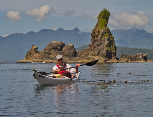
The Trial Islands are located just off the shores of Oak Bay in Victoria, on Vancouver Island, British Columbia. Kayaking there is truly one of the best day paddling trips in the area. The trip isn’t long, the scenery is amazing and the paddling can be a lot of fun because of the strong tidal currents flowing around the islands. The trip can easily be done in 1 or 2 hours!
The History
There are a couple of theories as to where the Trial Islands name came from. One suggests that navigating around them was a ‘trial’ of skill in seamanship and navigation due to the rip tides and prevailing westerly’s. The other is they were the destination for ‘trial runs’ for newly refitted Royal Navy ships from the Royal Navy Dockyards in Esquimalt Harbour.
While we may not be sure of the name, we do know that the Trial Islands are a beautiful, unique and special place and because of this an ecological reserve was established to protect the very rare plant species located here. In fact, there are 28 species listed as rare and 15 of them listed as greatest rarity.
The reason for the abundance of rare plants is the Trial Islands are one of the few areas on the west coast of British Columbia to escape glaciation during the last ice age. Another area that escaped glaciation is the Brooks Peninsula on the North West Coast of Vancouver Island. Check out our post: Kayaking to the Brooks Peninsula.
Be prepared to spend the whole time in your kayak because landing on the Trial Islands Ecological Reserve is restricted and permission to land is required.
Trial Islands Lighthouse
Another feature that makes a trip around the Trial Islands worthwhile is the beautiful light station located at Staines Point on the southeast corner of the island. The lighthouse was built in 1906 and was fully automated a little over a hundred years later in 2009. For more information on the lighthouse check out: Friends of Trial Island Lighthouse.
Getting There
There is easy access to the water and good parking at McNeill Bay on Beach Dr from Oliver St to Transit St. If the tide is low and there is no wave action rolling in, there are stairs leading from the roadway down to the main beach across from St Patrick St and also a ramp and stairs near Oliver St. If the tides are high or you would like a a more sheltered launch you can drive further east to the 560 block of Beach Dr. There is another small parking area here and a set of stairs which will get you down to a small cove inside Kitty Islet.
The Paddle
The first of the small islands that make up the Trial Islands is only 1/2 nautical mile (0.9 km) from the beach at McNeill Bay. Paddling there looks very inviting and deceptively easy, especially on a calm summer day. But, therein lies the danger. Problems can occur for inexperienced paddlers in areas like this because they start out when conditions are perfect. However, on returning they are confronted by a dramatic change in the water conditions. Instead of the flat calm water they crossed earlier, they are faced with a raging turbulent river created by the current flowing more strongly or a change in the current’s direction which now flows against a breeze, creating steeper and larger standing waves.
Depending on the tides a lot water is pushed through Enterprise Channel, the passage separating the Trial Islands from Vancouver Island. Currents up to 3 knots (5.6 kph) can occur here. (Currents of 2 knots and above are considered strong for those not familiar with moving water). The eddylines and standing waves (tide rips) that form in this channel can easily capsize inexperienced or unwary paddlers.
The currents flowing around the southern tip of the Trial Islands are even worse, particularly on the flood tide (rising tide). Currents up to 6 knots can be found here. That in itself will be serious problem for an inexperienced paddler, but combined with a wind blowing in the opposite direction or add some swell from the Juan de Fuca Strait and conditions here can become dangerous.
If you have done your homework, you’ll will have checked the current tables and the forecasted winds for the day before setting off so you will have a better idea of what kind of conditions you can expect. That and the direction of the current will determine which way you may want to circumnavigate the island.
For example, if the currents are running strongly on the flood, when it is the most fun to paddle, I will ferry across Enterprise Channel staying high to the west side and work my way around the northwestern tip of the islet on Enterprise Channel. From here I will paddle down the west side of the Islands. This sets me up to ride the flood around the southern tip of the island. On the return I will work my way up the narrow channel separating the islets, working the eddies back to the west side of the islands. This will set me up in a good position to cross Enterprise Channel back to MacNeill Bay.
For a more comprehensive explanation on planning a trip to the Trial Islands check out the post I did for Ocean River Sports.
Whether you pick a perfect day and have a nice leisurely paddle or you plan to go when the currents are raging for some adventurous rough water fun, the Trial Islands are a great choice, not only for the paddling but for the scenery!
Happy Paddling!!
Bruce
Map


Leave A Comment