Exploring the Sunshine Coast
For years we have talked about exploring BC’s Sunshine Coast and for various reasons, including bad weather, (it’s not always sunny there), we never made it. As the crow flies, the Sunshine Coasts runs about 160 km from Langdale in Horseshoe Bay, to Lund. However there are many more miles of meandering roads and 3 ferry rides involved to see the whole coast, not mention countless miles of beaches, inlets and coves to be explored. Since it was still fairly early for us to be heading north and the weather was forecast to be glorious, we decide this would be a good warm-up for our Alaskan RV adventure.
After two days of delays in Victoria to solve some equipment problems, we finally hit the road with Comox, BC as our first stop. From there we would catch the ferry to take us across the straits of Georgia to Powell River and the start of our exploration of the Sunshine Coast.
Powell River to Lund
After departing the ferry in Powell River, we made the short 25 km drive to our campsite at the Dinner Rock Recreation site just a few kilometers south of Lund. The road down to this site is incredibly steep and quite long. Even driving slowly in 1st gear, our left front brake was smoking badly by the time we reached the bottom. We found an amazing spot up on the shore facing the Straits of Georgia and Savary Island with the snow capped peaks of Vancouver Island forming the backdrop. After setting up camp and grabbing a quick lunch we drove into Lund to have a look around. Lund is a very small, quaint little village. However, not much there beyond the government wharf and boat docks, the Lund Hotel, and a couple of very cute restaurants on the water, one of them connected to the main harbour by a boardwalk. Lund is popular as one of the starting points for boaters heading into Desolation Sound and over to Savary Island. On the way back we dropped in to Okeover Provincial park, on the other side of the peninsula, to check out the camping there, which wasn’t great – basically tenting only. This is the other major access point into Desolation sound and is the starting point for kayaking trips into this area. Desolation sound is reknown for its calm, sheltered and very warm waters, unusual for the west coast.
Kayaking to Savary Island
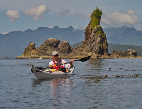
The next day we decide to do some kayaking. There is a very steep rocky boat launch at the Dinner Rock Campsite, thank god for the Honda CRV. We were able to load the boats and back down to the beach. The launch was pretty gnarly too, over large rocks and boulders. However, once on the water it was spectacular. Warm, sunny and flat calm. A perfect day to explore Savary Island, also referred to as Canada’s tropical island. While the vegetation isn’t very tropical, it is surrounded by miles of large white sandy beaches, especially at low tide, which does give it a tropical feel The north side of the lsland is steep sandy cliffs lined with cottages, while the north shore is lower bank shoreline. The whole island has a lot of cottages and homes, all connected by gravel roads. There is a general store and pub on the island, but apparently it is only open during the summer. There is no power or water on the island, so everyone is powered by solar panels or generators.
Nothing ends a good day of paddling better than sitting around the campsite enjoying the spectacular view while sipping on Margaritas. Follow that with a nice bottle of wine, an awesome batch of nachos, and you are in paradise!
Lund to Saltery Bay
Leaving dinner rock we poked around Powell River for a bit. Powell River is basically a mill town, but there are some interesting old buildings and homes around. The breakwater at the mill is also interesting, as it is comprised of the hulks old WWII ships all made with concrete hulls. Since the waters in front the mill are very deep, these hulks are all floating and anchored in place. Beyond that and some shopping for groceries and a few items, that was pretty much it for Powell River.
From Powell River we drove to Saltery Bay Provincial Park, not far from Saltery Bay where the ferry to Earls Cove on the lower Sunshine Coast docks. It’s a nice little park, and a short walk from our campsite takes you to Mermaid Cove, a beautiful little cove and rocky peninsula within the larger bay. This is a very popular dive spot and there is a statue of a mermaid down at 60’. We ran into a group of artists painting the location while we were there.
Saltery Bay to Sechelt
The next day we woke up to our first cloudy, misty day of the trip as we headed for the ferry to take us to Earl’s Cove on the lower Sunshine Coast. We were going to go check out the Skookumchuk rapids but changed our minds because of the weather, and the fact the tide was going to be slack and starting to flood by the time we got there, so there really wouldn’t be anything to see. I would love to surf the huge wave that forms at the head of the rapids one day, but you definitely need a paddling buddy or two to paddle these rapids safely.
On our way down the coast on the way to Earl’s Cove, we detoured through the Garden Bay resort area. Beautiful as this area is, we found the whole spot a little disappointing. It just lacks something…that flavor and charm you would expect of a place like this just isn’t there. Instead most of the buildings are of ugly design and not well maintained.
Sechelt is a nice little town though. The west shore of town is located on a huge gravel beach running the length of the town and beyond, While the east side reaches to beautiful Porpoise Bay, with a marina, float plane dock and a pub on the water. There also a provincial park a few kilometers up the road.
Sechelt to Langdale Landing
After leaving Sechelt, we chose to stay in Roberts Creek Provincial Park, about 15 km outside of Gibsons. Once we got camp setup we drove into town taking the back road through Roberts Creek, which is a very pretty drive. Taking this route you drive past the very quaint Gumboot Restaurant. Gibsons is a neat little town built on the steep slopes facing Keats Island and the Straits of Georgia. Of course Molly’s Reach, of Beachcombers fame, is still operating and looking just as it did in the 1972-1996 TV show. There are some other intriguing restaurants on the water including a BBQ shack on the public dock beside the harbor office and Smitty’s Oyster House down on the beach. There is also an assortment of little shops and café’s, pubs etc on the streets close by.
We decided to try Molly’s Reach, as corny as that may sound, but it is rated by Trip Advisor as the # 3 restaurant in town of about 34. The food was good and the service very pleasant. It is a neat little restaurant.
Once we got back to camp, the Parks guy came around to collect the campsite fee, as it was the opening day for the park. Bummer, no more free camping! He tried to scam another 10 dollars out of us for our tow car on top of the 20 for the campsite. We told him that was ridiculous as there are only two of us and it is our tow vehicle and not another camper. He eventually gave in, but didn’t seem convinced. You are allowed a tow car without having to pay for it. In all fairness I think people may try to scam them once in while, but it is pretty easy to see there were only two of us and there is towing gear on the car and the RV. (He looked new and possibly had an idea that a tow vehicle was supposed to tow a trailer etc.!)
The next morning, once again overcast and misting, brought us to Langdale Landing and the ferry ride to Horseshoe Bay on the mainland, to begin our trip north to The Yukon and Alaska.
[/fusion_text][/fusion_builder_column][/fusion_builder_row][/fusion_builder_container]


Leave A Comment